By: Chris ⎜ Last updated

Lofoten has somewhere between 30 and 50 established hiking trails, depending on who's counting and whether you include the ones that require using your hands to get up. Every peak starts near sea level and most of them deliver a ridiculous view for relatively little distance. Note that little distance does not mean little effort. Many trails don't bother with switchbacks. They go straight up from sea level, often gaining 300 to 500 metres in a kilometre or two.
Your problem will be choosing which ones to scale. A week-long trip with decent weather might give you four or five hiking days. The hikes below are the ones worth building your days around. Some are famous and earn it. Some barely show up in the guides but outperform the famous ones on everything except Instagram reach. They all involve steep, rough terrain with no switchbacks and weather that can change inside twenty minutes, so check yr.no on the morning of your hike and don't trust last night's forecast.
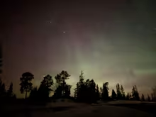
During the midnight sun season (late May through mid-July), there's as much light at 21:00 as there is at 09:00, and far fewer people on the trail. The best hiking window in Lofoten is early morning or late evening. In summer go late evening after dinner and have the mountain to yourself. Don't worry about it getting dark, in June-July there are 24 hours daylight. And if the sun is up, the evening and night light is amazing for photography.
Offersøykammen
The summit gives you a full 360-degree panorama with fewer hikers than the more popular trails: Haukland Beach to the north, the mountain wall of Flakstadøya to the west, the flat farmland of central Vestvågøy stretching east. On a clear day you can trace the entire chain of islands. No other hike in Lofoten puts it all in front of you at once like this, and you'll share the summit with a fraction of the people you'd find on Reinebringen.
Park at the Skreda rest area on the E10, which is free, has toilets, and has space for about 20 cars. From Skreda, the original trailhead is roughly 600 metres east along the road. Look for it just above a cluster of red fisherman's cabins on the opposite side of the E10. Some newer trails have formed closer to the Skreda parking in recent years, cutting straight up the hillside, but the original route is less steep at the start and easier to follow.
The trail is unsigned. Having a GPS track or offline map loaded before you start is worth the two minutes of preparation. Once you're on the path, the first section climbs steeply through birch trees before opening up into rockier, more exposed terrain. There's a false summit about two-thirds of the way up that deflates a lot of hikers. Keep going. The actual summit has a broad, flat top with room to spread out, eat lunch, and take in the view from every angle. Stay well back from the cliff edge on the north side, especially if there's wind.
The descent is where Offersøykammen gets people. Those rocky sections that felt fine on the way up become ankle-turners when you're heading down and gravity is working against you. The steep lower section through the birch trees is the worst stretch. Trekking poles help significantly.
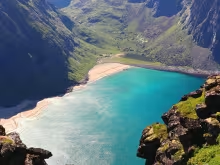
Ryten
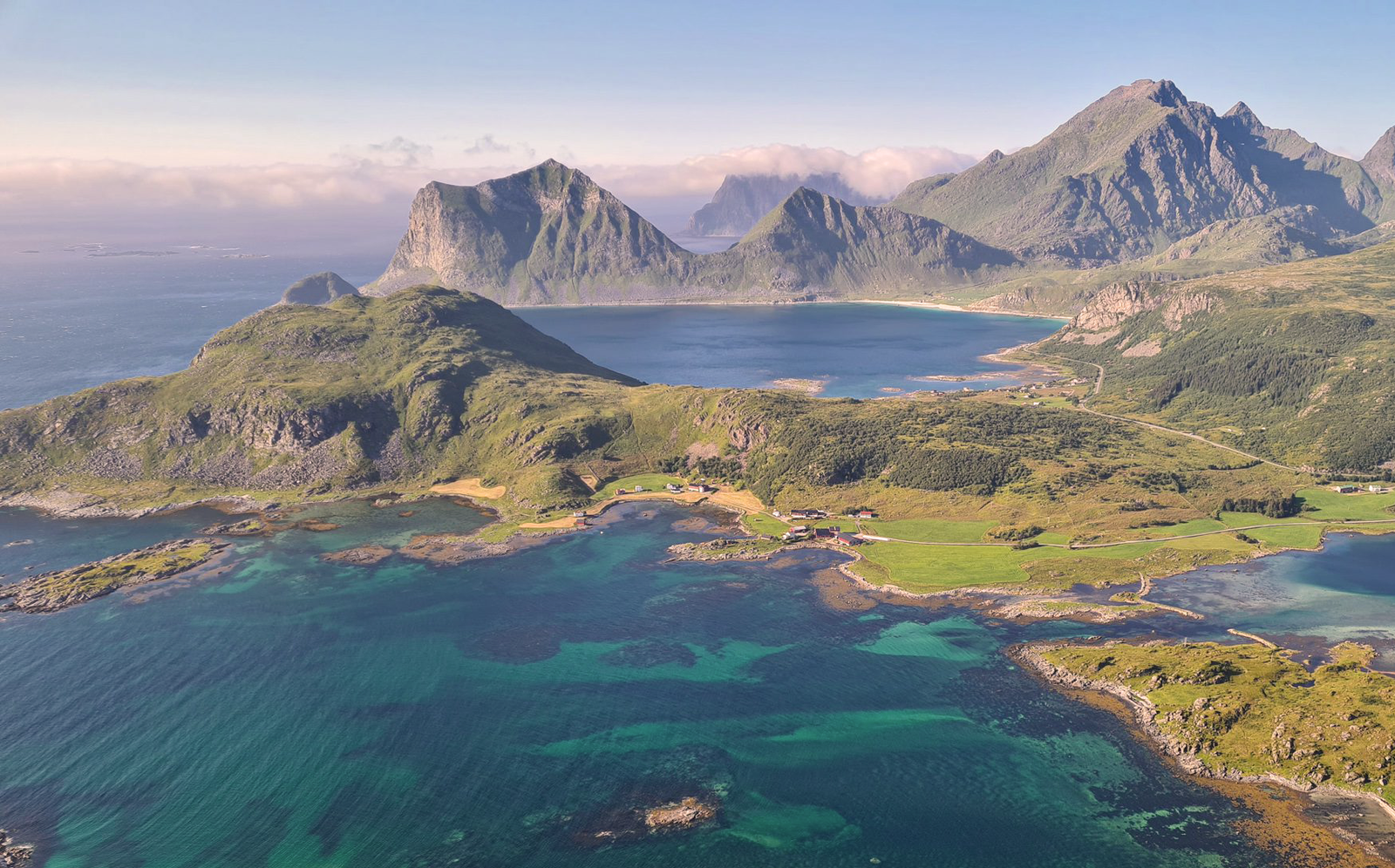
Most Lofoten hikes are essentially a climb to a viewpoint and back. Ryten is different. Boardwalks over boggy ground, grassy meadows, a lake, a proper sustained climb, and then a summit that drops away on one side into a sheer cliff overlooking Kvalvika Beach. The view from the top, with that turquoise water and white sand framed by vertical rock walls, is the image that's been replacing Reinebringen on Lofoten tourism posters.
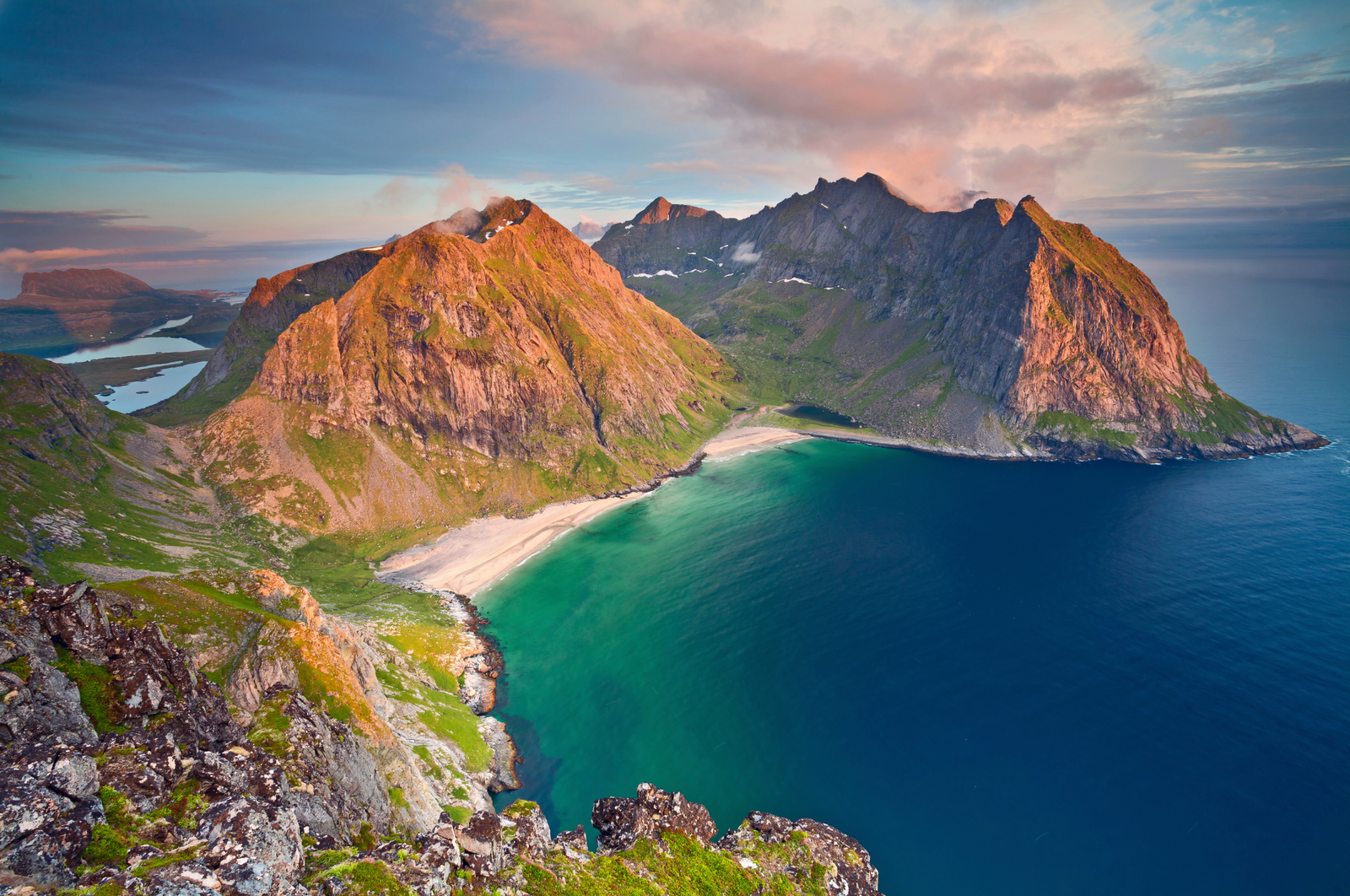
The direct route starts from the paid parking at Innersand, near the village of Fredvang, reached via the scenic Fredvang Bridges. There's also a smaller trailhead at Torsfjorden on the other side of the mountain, with about 16 marked spaces, which works better if you're staying in the Reine area and want to approach via Kvalvika Beach first. The Innersand route is the more popular start because it's gentler in the opening section, and lulls you into thinking the whole thing will be relaxed. It won't. The final push to the summit is a long, exposed climb with the wind blowing directly into your face on most days. In July, even with sunshine, the wind chill at the top can make you reach for that extra layer you almost left in the car.
About 2 kilometres in, a boardwalk trail forks off to the left toward Kvalvika Beach. The beach looks spectacular from above. Up close, it's less remarkable, and the detour adds at least two hours plus a steep, rocky descent and re-ascent. Skip the beach detour unless you're making a full day of it with 6+ hours.
Near the summit, you'll spot the photo rock: a jutting slab that looks terrifyingly exposed in photographs but is actually much less dramatic in person. People queue to take the shot in peak season. It's fun if the rock is dry. Don't bother if it's wet.
The Innersand lot is small and the spaces go quickly in July. Arrive before 09:00 or you'll be circling. On the road back toward Ramberg after the hike, there's a food truck near the Fredvang Bridges that makes decent wraps. It's the most reliable post-hike food option in the area, since the closest proper restaurants are in Ramberg or Reine.
Coming back down the same route, the steep section above the lake is loose gravel that slides underfoot, so slow down and watch your footing. The boardwalk sections lower down are a relief. For experienced hikers who want to avoid retracing the route, a loop via Kvalvika Beach and the Skåren pass back to Torsfjorden adds distance and requires route-finding confidence, but saves you the out-and-back repetition.
Mannen
The right call when the weather cooperates but you don't want to commit to a half-day mountain mission. Mannen sits on a ridge between Haukland Beach and Uttakleiv Beach, and the view from the trail covers both. Haukland has regularly appeared on best-beach-in-Europe lists, and from partway up Mannen you'll see why. The white sand, the pale green water, the jagged peaks boxing it all in.
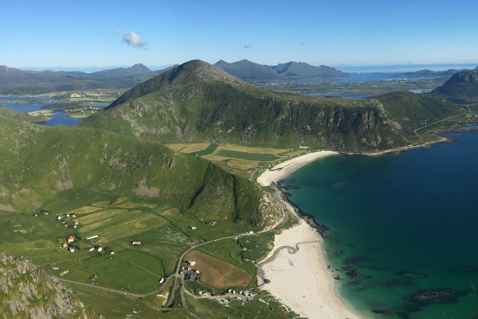
The trail starts directly from the Haukland Beach parking lot. It's a small lot shared with beachgoers and campers, so arrive early. You gain most of the elevation early, before the trail opens onto a broad ridge. This middle section is pleasant, relatively flat walking with views opening on both sides.
The last stretch to the summit is where the character changes. The ridge narrows, with exposure on both sides and some sections where the trail runs uncomfortably close to steep drop-offs. In dry, calm conditions, it's fine. Anyone comfortable with heights won't think twice. But in wind or rain, the exposed ridge becomes unpleasant, and there's nowhere to shelter. This is not a bad-weather hike.
The descent demands attention on the narrow ridge section. Going up, you're focused on what's ahead of you and the exposure barely registers. Coming down, you're looking directly at the drop-offs on either side and the steepness of what you just climbed. It's the same trail, but it feels different when gravity is pulling you toward the edge rather than into the hillside. Once past the ridge, the lower trail back to the beach is straightforward.
Mannen pairs naturally with Offersøykammen for a two-hike day if you're based anywhere near Leknes or Ballstad. The drive between the two trailheads is about 13 minutes.
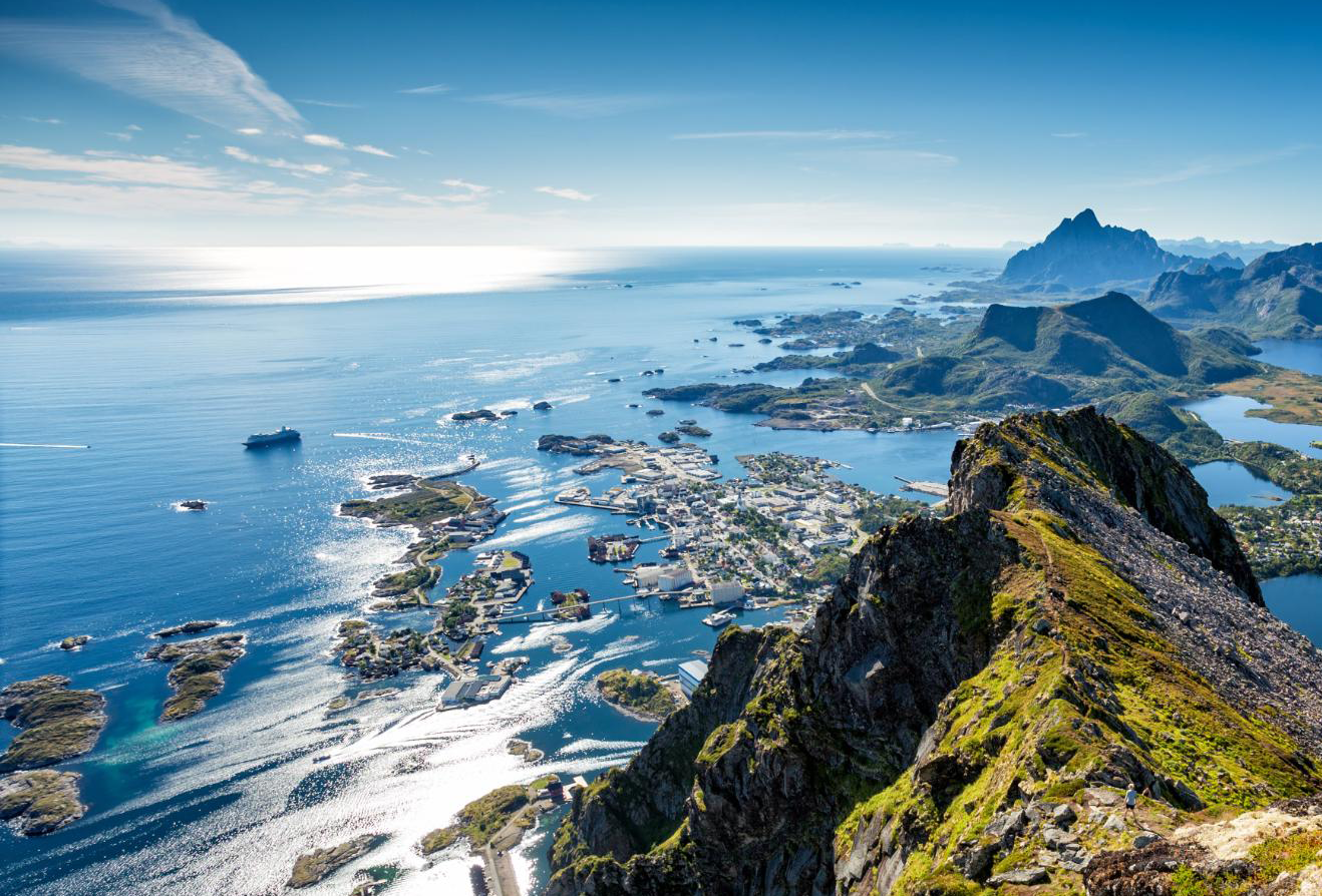
Fløya and Djevelporten
No car needed. The trailhead sits on the edge of Svolvær, reachable on foot from the town centre in about 20 minutes, and the route takes you past two of the most distinctive features in eastern Lofoten: the Svolværgeita (a twin-horned rock pinnacle popular with climbers) and Djevelporten (a massive boulder wedged between two cliff faces, forming a natural arch).
There's a paid parking area at the Blåtindveien trailhead, but spaces are limited and mostly gone by mid-morning in summer. Use the EasyPark app to pay. If you'd rather skip the parking hassle, walk from town or from the ferry dock.
The Sherpa-built stone staircase, known locally as Djeveltrappa (the Devil's Staircase), handles the first and steepest section of the climb. The stairs are well-built and even, with benches at intervals for catching your breath. Above the stairs, the terrain shifts to rockier ground requiring some navigation. From here the trail splits: one path leads right toward Svolværgeita (a technical climbing route, not a hiking destination), and the other continues up to Djevelporten and then along the ridge toward the Fløya summit.
This hike has two natural stopping points. Djevelporten is reachable for most reasonably fit hikers, and it's a legitimate destination on its own. The view from the ridge at Djevelporten is excellent, the rock arch makes for a memorable photo, and turning back here gives you a satisfying 2 to 2.5 hour outing.
Getting from Djevelporten to the Fløya summit (590m) is a different proposition. The ridge is narrow, the trail runs close to cliff edges, and the last few metres to the very top require scrambling with your hands. Anyone who doesn't like exposure should stop at the lower viewpoints along the ridge, which offer nearly identical panoramas over Svolvær and the surrounding fjords. There's no shame in stopping before the summit, and the views from 40 metres below the peak are just as good.
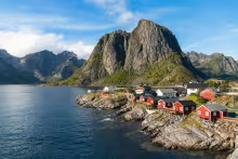
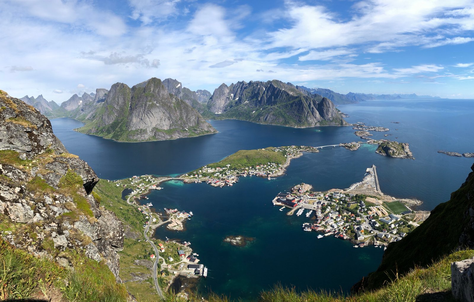
Reinebringen
Over 41,000 people hiked Reinebringen by June 2024, a 50% jump from the previous year. That number tells you two things: the view from the top really is that good, and you need a plan to enjoy it.
The view is the entire point here. Almost 2,000 stone steps, built by Nepalese Sherpas between 2016 and 2021, climb straight from sea level to a ridge overlooking the Reinefjorden. At the top, Reine and Hamnøy are spread across islands in bright coastal water below you, backed by the vertical granite wall of the Lofoten mountains. It's the most photographed view in Norway, and it earns every bit of that reputation.
The physical experience is something people consistently underestimate. This is a crossover between a StairMaster and a hike. The repetitive stepping motion, nearly 2,000 identical stone steps with no variation in terrain, is more punishing than a standard steep trail of the same elevation. Your quads will be screaming halfway up, and people who hike regularly are routinely surprised by how hard this hits their legs.
Parking is the real challenge. Three options: the Djupfjord viewpoint (free, 1.3km walk to the trailhead, often full of campervans), Ytre Havn in Reine harbour (hourly rate, paid via EasyPark app), or Reine Kultursenter (flat daily rate). Do not park along the E10. The fine is steep and heavily enforced. If you're staying in Reine, Sørvågen, or Hamnøy, just walk to the trailhead instead.
The first viewpoint on the ridge, where most people stop and take the famous photo, is not the actual summit. The ridge continues beyond it, and reaching the true summit of Reinebringen involves crossing two narrow sections where the path is only 50 to 60 centimetres wide with steep drops on both sides. Most hikers should stop at the first viewpoint. The photo is the same one you've seen online, and the risk-reward of continuing doesn't add up for anyone uncomfortable with exposure.
The descent is punishing. Those same steps that were merely exhausting on the way up become knee-destroying on the way down. The repetitive impact of stepping down nearly 2,000 stone stairs hits the quadriceps and knees hard. Trekking poles would be useful here. Budget at least 45 minutes for the descent even if you moved quickly on the way up.
Rain makes the stone stairs dangerously slippery and eliminates the view entirely, so there's no reason to attempt it in bad weather. Camping on Reinebringen is banned.
Read more about hiking Reinebringen and how to beat the crowds
Longer options and quieter alternatives
For hikers who want a proper full-day mountain outing, Munken (775m) starts from Sørvågen at the far western end of the E10. The trail passes through lakes, waterfalls, and chain-assisted rock sections on the way to a summit with panoramic views over the Reinefjorden and the highest peaks on the island. Allow 5 to 7 hours return, and treat this as a good-weather-only commitment. The Munkebu mountain hut along the route was closed for the entire 2025 season due to vandalism. Check the Lofoten Turlag website for current 2026 status before planning an overnight. Wild camping near the hut area is still permitted.
If you're staying in the Ballstad area and want something quieter, Nonstinden is a peaceful alternative where the parking lot is likely to be empty and the trail is yours. It won't have the dramatic summit panoramas of the hikes above, but the solitude is its own reward on an island chain where most popular trails feel increasingly crowded in peak season.