By: Chris ⎜ Last updated
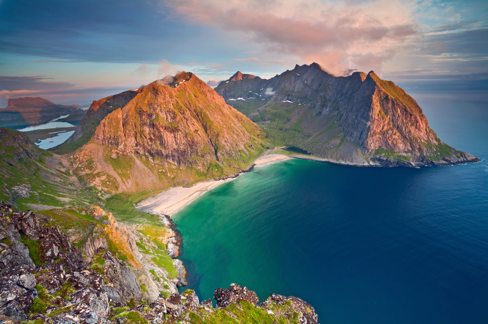
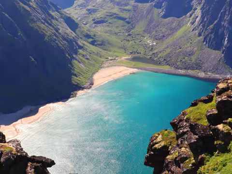
Ryten is one of Lofotens best summit hikes that ends at one of the most photographed iconic viewpoints in Lofoten. From the top, you look straight down at the curved white sand of Kvalvika Beach, turquoise water backed by sheer coastal cliffs, and the Norwegian Sea stretching out in every direction. The trail itself covers grassy slopes, rocky ground, and wooden boardwalks laid across boggy sections. Round trip takes three to four hours. A moderate hike, not a scramble, and less punishing than the Reinebringen staircase near Reine.
During peak summer, this trail is packed. The parking areas near the trailhead fill up fast, the path gets congested, and the lower sections turn into a muddy mess after any rainfall. Erosion is visible and ongoing. If you're imagining a solitary wilderness experience, recalibrate. On a sunny July afternoon, you'll share the summit with dozens of other hikers jostling for photos at the overhanging rock near the top. That rock creates an optical illusion of a sheer drop and makes for a dramatic photo, but it's also a bottleneck where you might wait 15 minutes for your turn.
Best time to hike
Arrive before 8 AM or after 4 PM in summer. The early and late windows solve two problems at once: parking availability and crowd density. During the midnight sun period, roughly mid-May through mid-July, hiking at 9 or 10 PM is entirely viable and the low golden light makes for better photos anyway. You'll have the trail mostly to yourself.
The summit is fully exposed to coastal winds. Even on a calm day in the valley, expect gusts at the top. Low clouds can roll in fast and erase the view entirely, so check yr.no before committing. If the summit is socked in, you're doing a three-hour round trip for grey nothing. Weather windows in Lofoten can be narrow, so be flexible with your schedule and ready to go when conditions align.
Getting down to Kvalvika
You can extend the hike by descending from the Ryten viewpoint area down a steep path to Kvalvika Beach itself. The descent is loose and steep, and climbing back up is the hard part. Add at least an extra hour or two for the round trip down and back. If you just want to stand on that white sand you've been staring at from above, it's worth it, but plan your energy accordingly. Sheep graze the grassy sections along the way, unbothered by hikers.
Parking and getting here
The main paid parking at Innersand costs around 100 NOK. Payment is usually by card or Vipps, the Norwegian mobile payment app, though Vipps requires a Norwegian phone number so most international visitors will need to pay by card or cash. If the main lot is full, there's a free rest stop back near the Fredvang bridges, but it adds a significant walk along the road to reach the trailhead.
Parking illegally along the narrow roads near the trailhead is a real problem here, and police run regular checks in summer. The fines aren't cheap. Use the official lots.
A rental car is the only practical way to get here. Buses serve the E10 but the nearest stop is Fredvang, which leaves you with a 4 to 5 km walk just to reach the trailhead. Budget about 25 minutes from Reine.
What to bring
There are no toilets or facilities on the trail and no water refill points. Pack everything you need: water, snacks, sunscreen, a windproof layer, and sturdy hiking shoes with decent grip. Trail runners are fine in dry conditions. After rain, you want something waterproof with ankle support. The mud on the lower sections is the slick, boot-sucking kind.
Winter hiking is technically possible but requires microspikes, a headlamp, and solid navigation skills. Ice and snow cover the trail, and daylight is minimal from November through January. This is a summer hike for most visitors.
Ryten vs Reinebringen
If you're choosing between the two, Ryten is the easier and more varied hike. Reinebringen is roughly 1,978 stone steps straight up, relentless from start to finish. Ryten gives you rolling terrain, changing views the whole way up, and the option to extend down to Kvalvika Beach. Reinebringen rewards you with one of the most famous panoramas in Norway, looking out over Reine and the surrounding fjords, but it's a workout with less variety along the way.
What to do nearby