By: Chris ⎜ Last updated
Norway has 18 designated scenic routes called Nasjonale Turistveger (National Tourist Roads). They add up to 2,240 kilometres of roads that go along coastlines, over mountain passes, through landscapes the main highways skip. None of them will get you anywhere faster, but that's the point, the road is the destination in itself. The government has been developing these routes since the 1990s.
What sets these routes apart is the landscape and architecture. Starting in the 1990s, the Norwegian Public Roads Administration began commissioning serious architects to design the infrastructure along these roads. Not just functional rest stops, but everything from cantilevered viewing platforms to sculptural toilet buildings, and walkways suspended over gorges. The road authority basically commissioned architects, designers and artists, then scattered their work across mountain passes and remote coastlines, all free to visit.
The driving itself is part of the appeal. These roads weren't built for efficiency. Many sections are single-lane, with designated passing points. Hairpin bends drop at 9% gradients with minimal guardrails. Some stretches are carved directly into vertical granite, clinging to cliffs above fjords that drop hundreds of metres to the water. The driving to reach a viewpoint is as much a part of the experience as the viewpoint itself.
All 18 routes are spectacular in their own ways, but some are better, more accessible and more popular than others. These are in our opinion the best ones.
The best of the routes
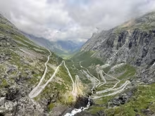
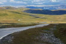
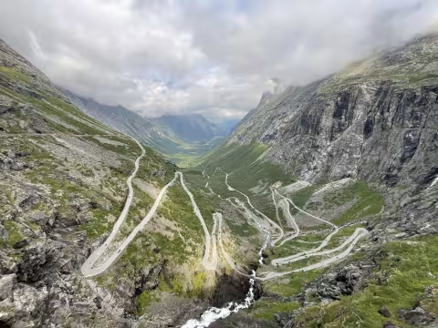
Geiranger-Trollstigen
104 km | 6-8 hours | One ferry crossing | Seasonal: mid-May to October
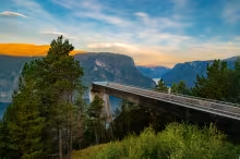
This road is the showpiece. Eleven hairpin bends up a mountain that shouldn't be drivable, two UNESCO-listed fjords, and architecture by Reiulf Ramstad and Jensen & Skodvin at the rest stops along the way. The Trollstigen Plateau visitor centre offers steel and glass walkways cantilevered directly over the hairpins, with the Stigfossen waterfall thundering beside you. This is the one everyone wants to drive, and for good reason.
Geiranger-Trollstigen scenic route self-driving
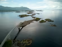
Atlantic Road
8.3 km (main section), 36 km (full route) | 2-4 hours | No ferries | Open year-round
Eight bridges hopping between skerries, waves crashing over asphalt in autumn storms. The most photographed span, Storseisundbrua, curves upward and then drops away at an angle that makes it look like the road simply ends in mid-air. The most accessible of the major routes: no ferries, no mountain passes, and fits easily into a day trip from Ålesund or Kristiansund.
Read the complete driving guide to the Atlantic Road scenic route→

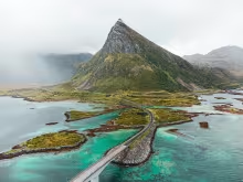
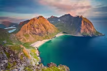
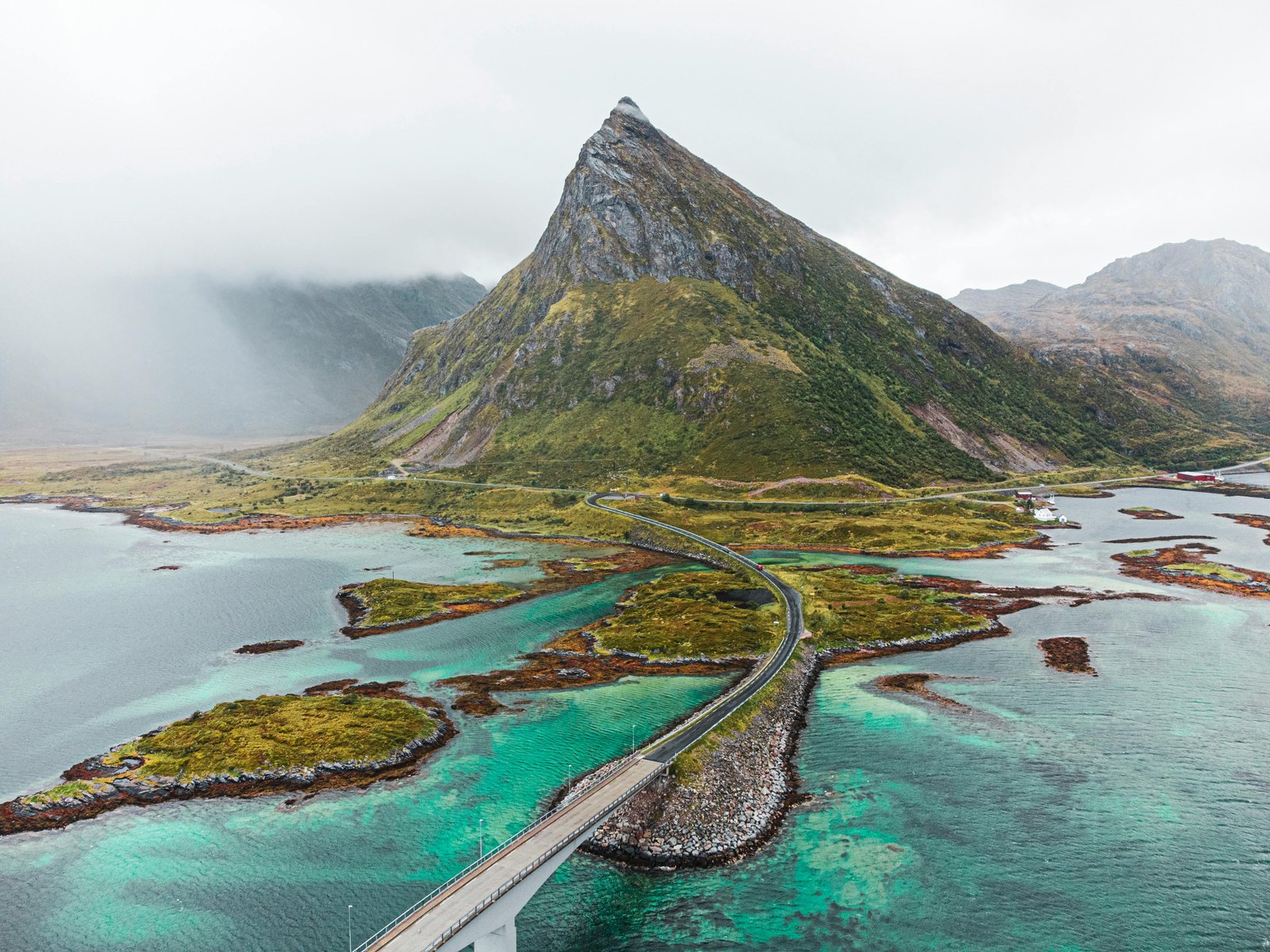
Lofoten
230 km | Minimum 3 days | Ferry to reach it | Open year-round
This is not a detour you add to another itinerary, but the main artery through an archipelago that is a multi day trip on its own. Vertical peaks rise directly from turquoise water, framing tiny harbours clustered with red fishing cabins and beaches that belong somewhere tropical. The E10 connects the islands via bridges and tunnels, with designated stops including Snøhetta's amphitheatre at Eggum and Manthey Kula's brutalist toilet building at Akkarvikodden.
Read the complete driving guide to the Lofoten scenic route →
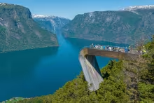
Aurlandsfjellet
47 km | 2-3 hours | No ferries | Seasonal: June to October
Also called The Snow Road as you can see snow from the road most of the summer. Climbs from Sognefjord to a plateau so barren and white it feels like another planet, then drops to Stegastein, the viewpoint you might have seen in the Norwegian tourism campaigns. The wooden platform juts 30 metres out from the cliff face, 650 metres above the Aurlandsfjord.
Read the complete driving guide to the Aurlandsfjellet scenic route →

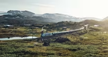
Hardangervidda
67 km | 2-3 hours | No ferries | Open year-round
Hardangervidda is Northern Europe's largest mountain plateau, dropping dramatically into Måbødalen valley past Vøringsfossen, Norway's most famous waterfall. The water plunges 182 metres from the plateau edge into the gorge below. Carl-Viggo Hølmebakk's 99-step bridge spans the river just above the falls, the architectural highlight of any scenic route in Norway.
Read the complete driving guide to the Hardangervidda scenic route →
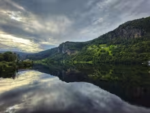
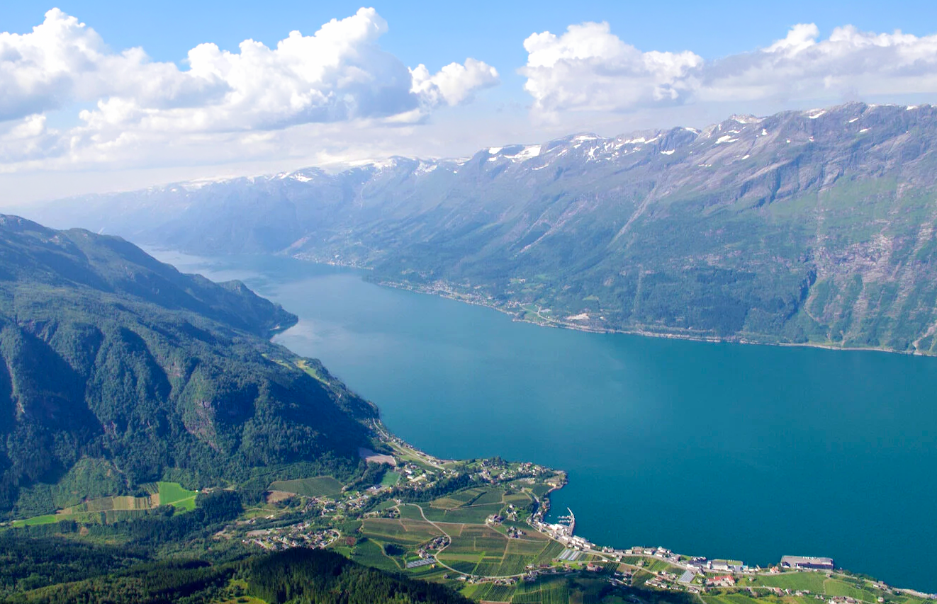
Hardangerfjord
158 km | 3-5 days (loop from Bergen) | One ferry crossing | Open year-round (best mid-May to September)
Often called the Orchard of Norway, this route swaps the sheer granite walls in the northern fjords for steep hillsides covered in apple, plum, and cherry trees. The drive hugs the water from Norheimsund down to Odda, passing working cider farms, traditional timber hotels, and architect-designed rest areas like Hereiane. Along the way, you can detour to walk on the Folgefonna glacier, hike Trolltunga or hike Queen Sonja's panoramic trail (Dronningstien). It´s less crowded than the famous Nærøyfjord, but it is quietly one of the best drives in the country.
Read the complete driving guide to the Hardangerfjord scenic route →
When to go
June to August: This time of the year the full network is open, and the weather is at its best: Trollstigen, Geiranger, and the high mountain passes have opened for the season. In Lofoten you have midnight sun. Every route is accessible, and the days are long. The trade-off is traffic, especially during Norwegian school holidays in July and beginning of August: campervan convoys clog the single-lane sections, and the best accommodation books out months ahead in popular areas.
Late May and September: Trollstigen typically opens mid-May, and in September you might catch autumn colours before the first snow closes the passes. The weather is colder and riskier, especially for mountain passes, which can close overnight after a snow storm.
October to April: Coastal routes stay open all year: the Atlantic Road, Lofoten's E10 and the Hardangerfjord road is open all year. In Lofoten you have Northern Lights season. Mountain passes that are physically gated shut: Trollstigen, the road into Geiranger and the Aurlandsfjellet Snow Road above Stegastein (the road up to Stegastein is open). The roads will close when the first serious snow arrives and stay closed until spring clearing crews finish, sometimes as late as June.
Universal logistics
Ferry payment
There are 3 different payments systems, and all are interchangeable:
Standard AutoPASS toll tags, the kind included in Norwegian rental cars, give you 10% off ferries and 20% off some toll roads. The crossings bill to your rental company, who invoice you later. If you're driving your own car, sign up for an AutoPASS tag from one of the approved suppliers, for example Flyt. Order one well in advance as it will be shipped to your home address.
AutoPASS-ferje prepayment gives you a 40-50% discount on most ferry crossings. This requires that you already have an AutoPASS tag. You pay a 2,200 NOK deposit upfront for vehicles under 8 metres, and each crossing deducts the discounted fare from your balance. Register at autopassferje.no. This makes sense for multi-week trips with many crossings. If you have any unused balance after your trip you can request a refund to your bank account.
FerryPay charges the full price to your credit card with no hassle. Just register your licence plate and credit card at ferrypay.no, then drive and forget about it. For a single crossing, this is the sensible choice.
If you do not sign up with any of these providers, you will be billed in arrears for all ferry crossings, with an added administrative charge on top and no discounts.
EV charging
Norway has excellent fast-charger coverage on main highways, but the scenic routes are different. In Lofoten and on remote coastal routes, chargers may be spaced 100+ kilometres apart. The stations in tiny coastal towns often have only 50kW chargers, and summer queues can be long. You should ensure your accommodation has destination chargers (most good places do at this point) to avoid having to rely on the fast charging network. For long drives, plan charging stops before you leave each morning using an app that shows real-time availability.
Driving conditions
Single-lane roads have designated meeting points, marked with blue signs bearing a white 'M'. When you meet oncoming traffic, whoever is closer to an M sign pulls in and waits. Sometimes this means reversing a bit.
Watch out for animals. Sheep and cattle are often wandering freely around and they don't check for cars. Be particularly careful at dawn and dusk. Speed limits peak at 80 km/h on open stretches, but winding scenic routes average 50-60 km/h.
Check vegvesen.no or download the NPRA traffic app before driving. Mountain passes can close without warning after heavy rain or unexpected snow.