By: Chris ⎜ Last updated
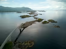
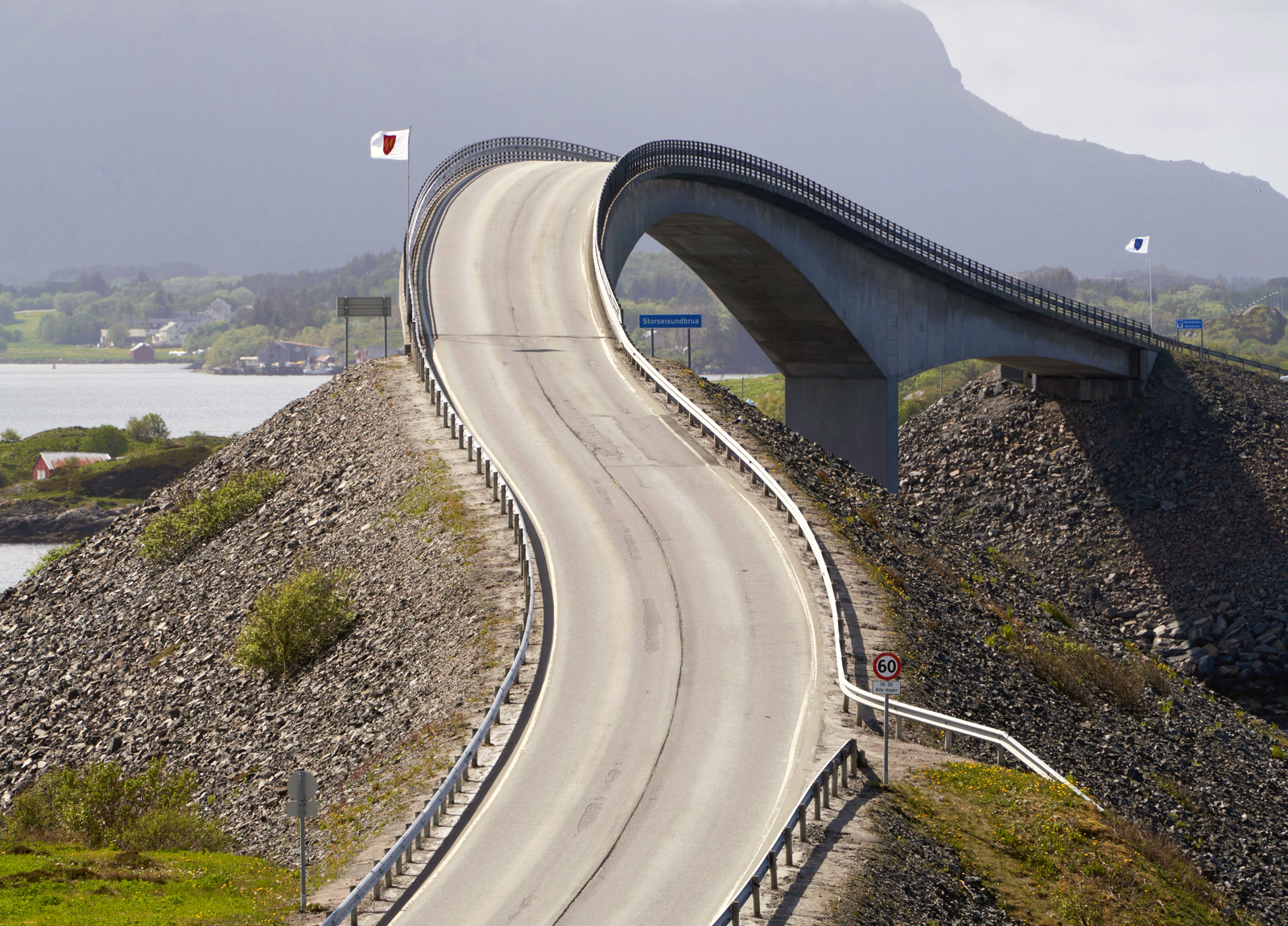
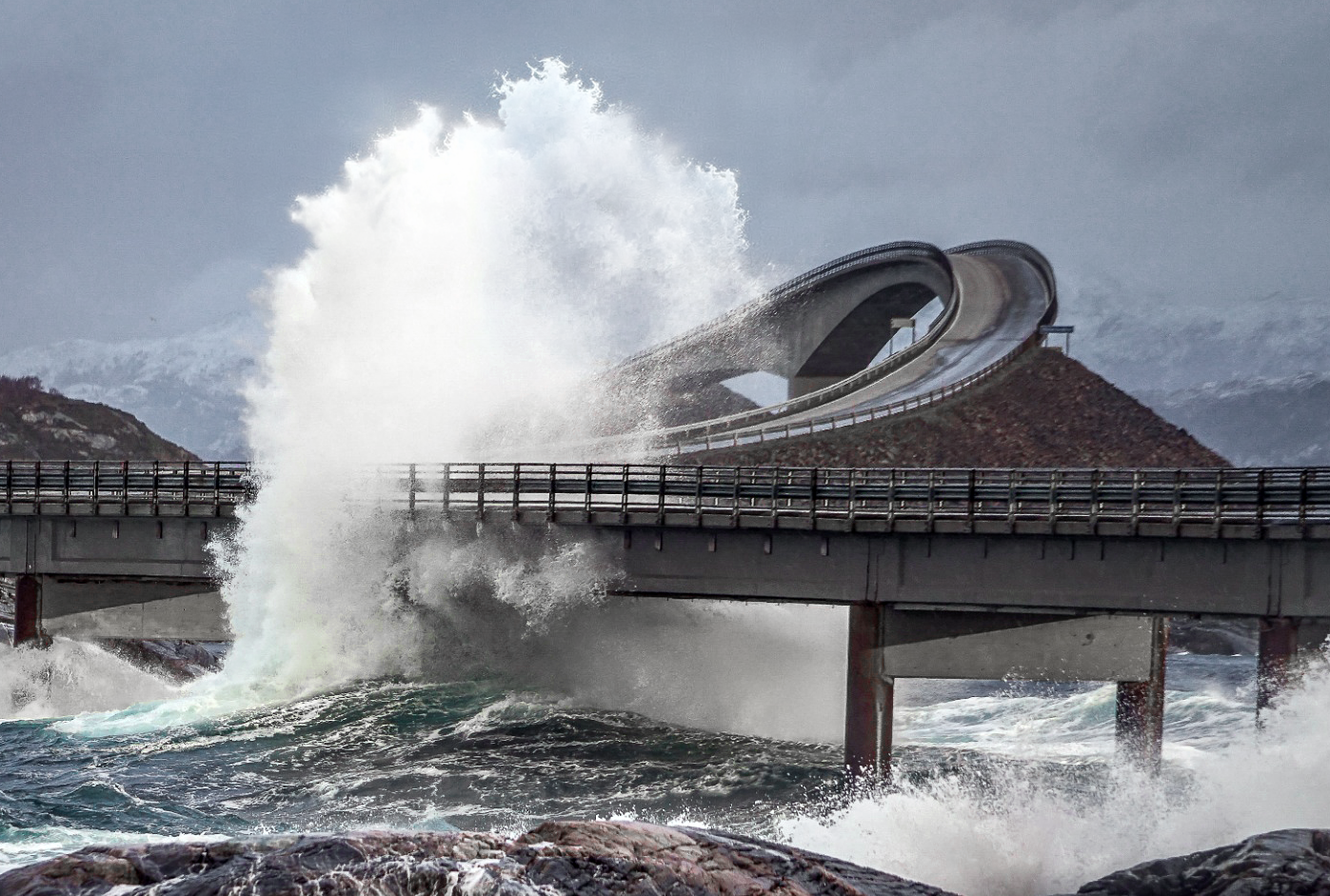
The Atlantic Road you've surely seen photos of. Eight bridges hop between tiny islands and skerries, waves crashing over the asphalt, spray soaking windscreens. The most photographed span, Storseisundbrua, curves upward and then drops away at an angle that makes it look like the road simply ends in mid-air.
Those photos are shot in autumn storms. If you visit in July, expect a pleasant, sparkling coastal drive. The bridges still curve dramatically, the sea still glitters, but nobody's getting soaked.
Quick facts:
- 8.3 km (main section)
- 36 km (full scenic route)
- 2-4 hours with stops
- No ferries
- Open year-round
The full route
The famous bridge section between Vevang and Kårvåg is only 8.3 kilometres. The designated scenic route runs 36 kilometres from Kårvåg in the north to the fishing village of Bud in the south, embracing the coastline and passing through fishing communities, cultural sites, and open moorland with views of the Hustadvika bay.
The road opened in 1989 after six years of construction that saw workers battle 12 hurricanes during the building process. Today it forms part of the 18 National Scenic Routes, enhanced by architect-designed viewpoints and rest areas.
Starting from Kristiansund or Molde
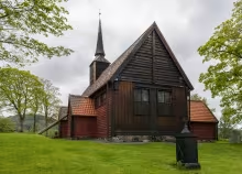
Coming from Kristiansund, you'll emerge from the Atlantic Ocean Tunnel onto Averøy island. Before hitting the main road, consider a 10 km detour to Kvernes Stave Church, an 11th or 12th century wooden church with medieval painted interiors, and the nearby Kvernes rural museum.
From Molde, the drive takes about 45 minutes through rolling farmland and along the edge of the Romsdalsfjord. The Atlantic Road sits roughly midway between the two towns, making it an easy day trip from either.
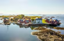
Håholmen Havstuer
Even better, start your journey with a night at Håholmen Havstuer. The hotel occupies an entire historic fishing village on a private island just off Geitøya, near the northern end of the road. You can't drive there. A boat picks you up from the car park and deposits you on the island seven minutes later. In summer, the crossing sometimes happens aboard the Kvitserk, a replica Viking ship.
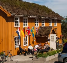
The village dates to the 1700s, when it served as a trading post for klippfisk (dried and salted cod). Today there are 47 rooms spread across roughly 25 historic wooden buildings, some of them converted barns and stables. The oldest date to the 18th century. No rooms have TVs. The restaurant, Ytterbrygga, serves local seafood with the klippfisk still a specialty. The Silver Bell Pub handles lighter meals. A small museum tells the story of the island and its shipwrecks.
The hotel is open May through September. Boat transfers run on a fixed schedule in summer (roughly hourly from 11:00 to 21:00) and by appointment in the shoulder months. Day visitors can take the boat for 135 NOK, but the real point is staying overnight, watching the sunset over the skerries, and waking up somewhere cars can't reach.
Read our full guide to Håholmen Havstuer
Eldhusøya
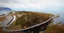
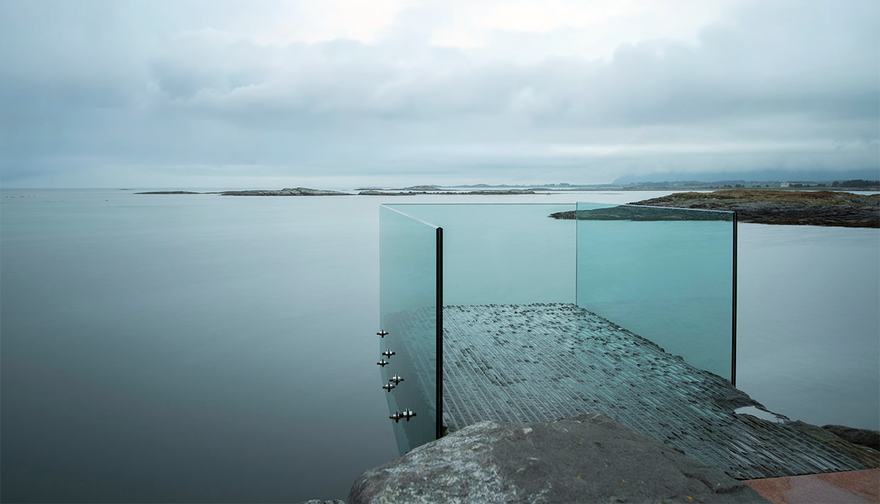
The largest rest area on the Atlantic Road sits on the islet of Eldhusøya, just before the Storseisundbrua bridge. A 700-metre elevated boardwalk designed by Ghilardi + Hellsten loops around the island, floating above the rocky terrain to protect the fragile marshland beneath. The walkway is equipped with viewing platforms positioned to frame the entire bridge sequence.
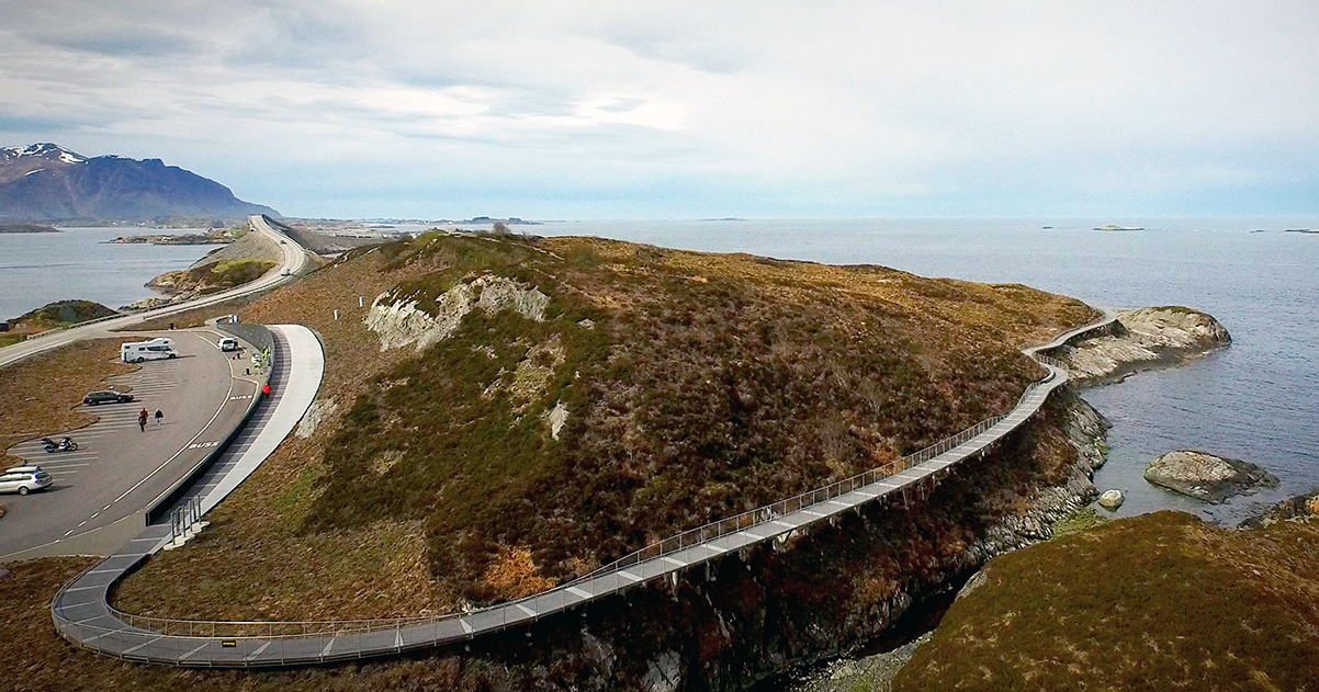
The service building below the walkway has a café (open daily June through August, weekends in spring), tourist information, and year-round toilets. The 150-metre facade features abstract herring patterns referencing Averøy's fishing heritage.
Allow at least 30 minutes here. Walk the full loop, and if the weather cooperates, this is your best vantage point for photographs of the entire Atlantic Road sequence.
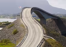
Storseisundbrua
At 260 metres, it's the longest bridge on the Atlantic Road, curving upward at a dramatic angle before dropping toward Averøy island. From certain approaches, optical illusion makes the bridge appear to launch straight into the sky, earning it the nickname "the drunk bridge."
There's no dedicated parking on the bridge itself. For the best photographs, shoot from Eldhusøya looking toward the bridge, or from the small pullouts on Averøy looking back toward the mainland.
Askevågen viewpoint
A little further along the route, the Askevågen viewpoint designed by Reiulf Ramstad Arkitekter provides large glass panels that protect visitors from spray while framing panoramic ocean views. Popular with photographers, particularly during rough weather when waves break against the rocks below.
Myrbærholmbrua and fishing
At Myrbærholmbrua, specially built fishing walkways extend from both sides of the bridge. During strong currents, the fishing is excellent: cod, pollock, mackerel, and coalfish are all common catches. If you're traveling with fishing gear, this is one of the few places in Norway where you can fish directly from a bridge over the open Atlantic.
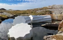
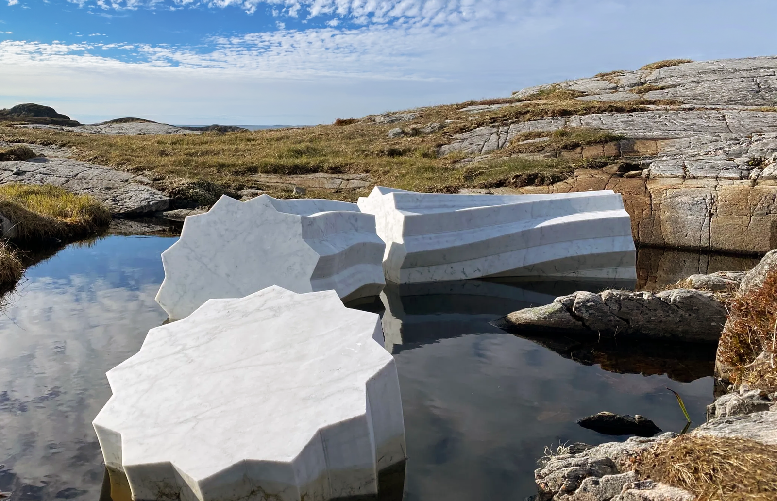
Hågå sculpture
On the rocks near the southern end of the route, a white marble sculpture by artist Jan Freuchen rises against the coastal landscape. Columna Transatlantica references the Midgard Serpent of Norse mythology, a sea serpent that encircled the earth. Easy to miss if you're not looking for it, but worth a brief stop for the contrast between contemporary art and the ancient shoreline.
Bud
The fishing village of Bud marks the southern terminus of the scenic route. The harbour was a significant trading post on the coastal route between Bergen and Trondheim for centuries. Today it offers a more tranquil atmosphere, with colourful waterfront houses and the Ergan Coastal Fort, a German-built WWII installation now restored as a war memorial museum.
Where to eat
Bjartmars Favorittkro is the best choice for a meal along the road. The restaurant sits on Averøy just off the Atlantic Road, about 30 km from Kristiansund, and operates out of a 170-year-old timber building with views over the water and a terrace for outdoor seating when the weather cooperates.
The menu leans heavily on seafood from local suppliers: halibut from Nordic Seafarms at Henda, klippfisk from Sigurd Folland on Kjønnøya, crayfish from the Romsdalsfjord. The house specialty is bacalao, which won first prize in a national competition in 2012, 2014, and 2018. If you're here on a Thursday, the potato dumplings (raspeball) are made from a family recipe and served with salted meat, sausage, and bacon. The Sunday buffet draws locals.
Opening hours are limited. The restaurant is closed Monday and Tuesday, open for lunch and early dinner Wednesday through Saturday (12:00-18:00 midweek, until 20:00 on weekends), and runs the Sunday buffet from 13:00 to 17:30. Check before you arrive. This is one of the few proper restaurants along the route, so it fills up during peak season.
Route-specific information
No tolls, no ferries: The Atlantic Road is completely free to drive. No ferry crossings, no toll stations. This makes it the most accessible of the major scenic routes.
Best conditions for photos: The dramatic wave-over-road shots require autumn storms (September through November). Summer offers calmer seas and better light.
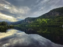
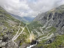
Combining routes: The Atlantic Road sits about 1.5 hours north of Åndalsnes, which is at the northern end of the Geiranger-Trollstigen Scenic route. A natural itinerary starts with an overnight in Kristiansund, drives the Atlantic Road in the morning, continues south to the Geiranger-Trollstigen route in the afternoon, and overnights in Geiranger, or the other way around.
Other scenic routes
Check out these other scenic routes in Norway. The Geiranger-Trollstigen route is the closest one to the Atlantic Road.
Geiranger-Trollstigen scenic route self-driving
Explore the locations