By: Chris ⎜ Last updated

The scenic route connects Geiranger to Ålesund via Trollstigen, a mountain pass with hairpin bends that is barely just drivable. It's exactly as dramatic as the tourism brochures claim. This is the most visited scenic route in Norway, and for good reason.
Quick facts:
- 104 km
- 6-8 hours minimum, depending on stops and ferry timing
- One ferry crossing (Eidsdal-Linge)
- Seasonal: mid-May to October
This route starts at the northern end, you can just as well flip the itinerary and start at Geiranger instead.
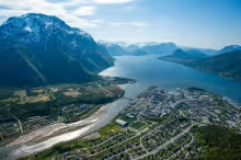
The drive from Åndalsnes
Start from Åndalsnes, the small town at the base of Romsdalen valley. The E136 runs through the valley floor with Trollveggen, Europe's tallest vertical rock face at 1,000 metres, to the south. The viewing area is a 5 minute detour from the scenic route, but not really worth stopping at, all you will see is a giant rock wall from below.
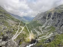
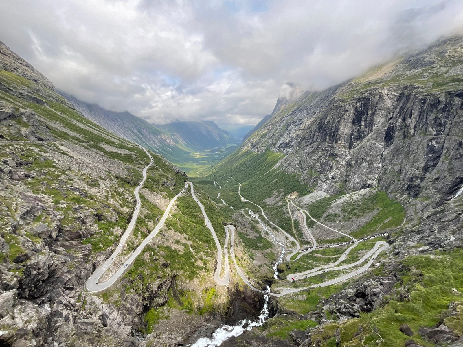
The road climbs from the valley floor into the hairpins of Trollstigen itself. Trollstigen is eleven switchbacks carved into a mountainside that rises up the mountainside, each named after the foreman who oversaw its construction in the 1930s. The gradient hits 9% in places, and the road is at places so narrow that meeting a tour bus or a camper van often requires someone to reverse. During peak season when traffic is high, this frequently creates deadlocks which takes several minutes to resolve. The Stigfossen waterfall crashes directly across the road surface, spraying mist over your windscreen.
Trollstigen Plateau
At the top, the Trollstigen Plateau visitor centre designed by Reiulf Ramstad Arkitekter sits like a piece of industrial sculpture against the rock. Steel and glass walkways cantilever directly over the hairpins. When you stand on the lower platform, you're looking straight down at the road you just drove, with the waterfall thundering beside you, and the peaks of Bispen (1,462m), Kongen (1,614m), and Dronninga (1,544m) on the horizon.
The visitor centre houses a café with panoramic windows and a souvenir shop. Toilets are also available here. Allow half an hour to one hour here, more if you walk the trails toward Bispevatnet lake.
Parking note: The plateau car park fills by mid-morning in summer. You should aim at getting here early.
Trollstigen can close without warning after heavy rainfall. Check vegvesen.no or the NPRA traffic app before you leave to be sure it's open.
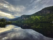
Valldal and Gudbrandsjuvet
Descending the south side of Trollstigen brings you into the strawberry-farming village of Valldal. The contrast is stark: one minute you're on an exposed mountain road, the next you're passing orchards and farmhouses in a green valley.
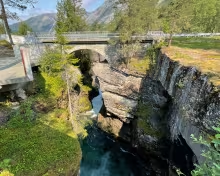
Midway between Trollstigen and the ferry terminal at Valldal, make a stop at Gudbrandsjuvet. This is a narrow gorge where Jensen & Skodvin Arkitekter built zigzag steel bridges that cross the ravine where the Valldøla river rumbles 20-25 metres below. The architecture here is different from Trollstigen: raw and industrial. The sound of the water echoes off the canyon walls, and in high summer the spray creates rainbows in the morning or evening light.

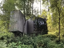
Juvet Landskapshotell
If you're going to spend one night on this route, spend it at Juvet. In fact we would recommend you plan your itinerary around it, it's a really special retreat, and two nights here are even better.
Read our guide to Juvet Landskapshotell
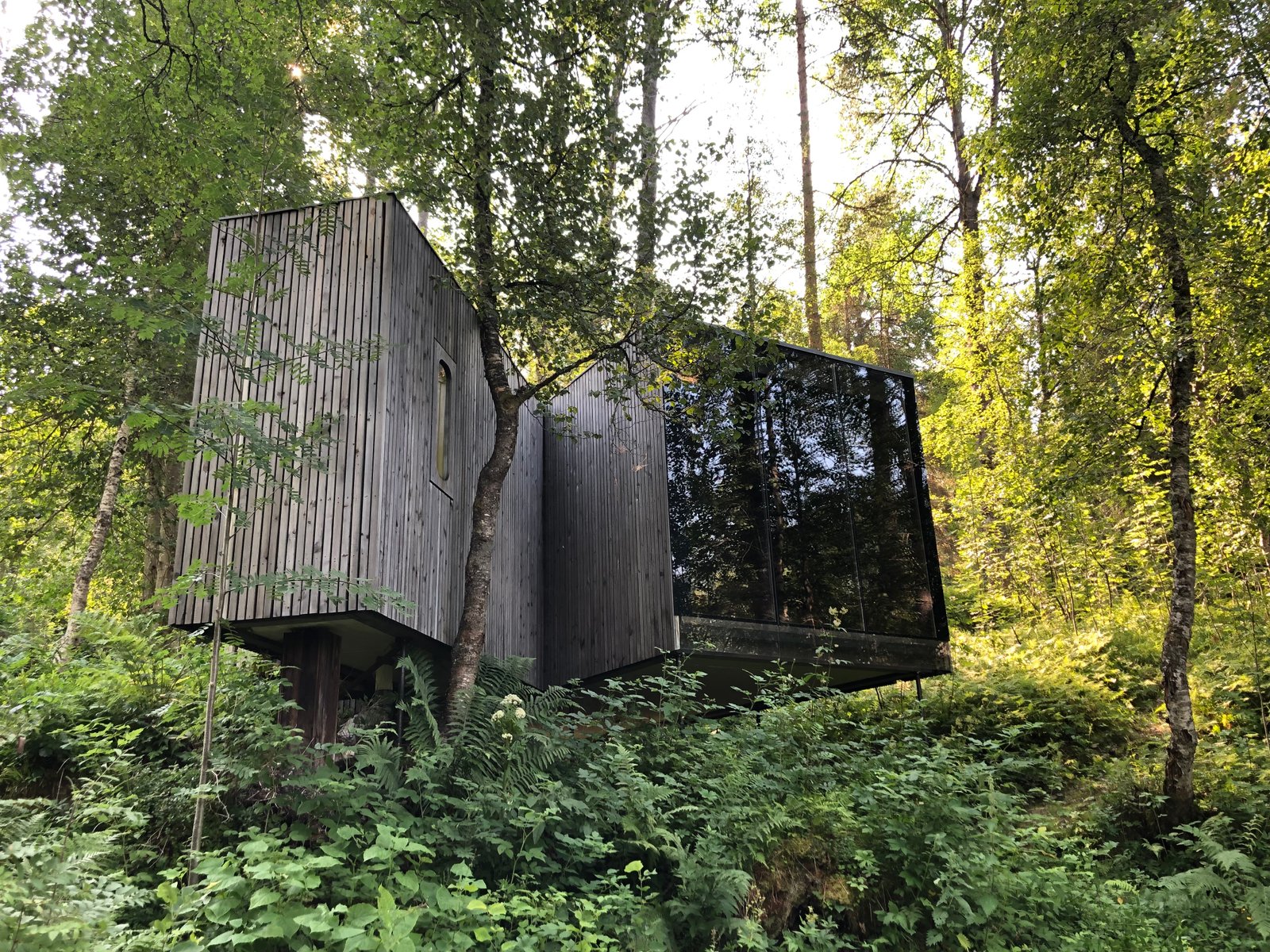
The hotel is located in a birch forest above the Valldøla river, a few minutes' drive from Gudbrandsjuvet, and it was designed by the same architects. There are seven glass-walled cabins perched on stilts among the trees, each one angled to frame a different view of the river, the forest, or the mountains across the valley. Two smaller "bird houses" sit a bit higher up. A restored 19th-century barn serves as the restaurant, where guests eat together at a communal table.
The rooms are deliberately minimal, and there´s no TV for distraction, you're here for nature and serenity. The walls are dark wood, the beds face floor-to-ceiling glass, and you fall asleep to the sound of the river. A bathhouse by the water has a steam room and outdoor hot tub with a 15-metre glass wall looking out at the current. The whole place feels like staying inside an architectural installation.
Juvet opened in 2010 and became briefly famous when Ex Machina used it as a filming location. You need to book well in advance. There are only nine rooms, which fill up months ahead in summer. Expect to pay from 6,000 NOK per night for a double. The dinner is extra, but the four-course communal meal is worth adding, it's the best meal in the area, and it's not like you have many options here anyway.
Juvet is right between Trollstigen and Geiranger, so you can drive the hairpins in the afternoon, check in, and continue to the fjord the next morning. It's about 30 minutes from the Trollstigen plateau and 90 minutes from Ålesund.
Where to eat
Two notable stops between Trollstigen and Geiranger, both in Valldal near Gudbrandsjuvet.
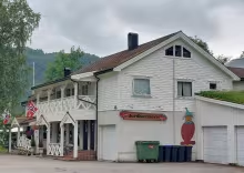
Jordbærstova is 5 km before Valldal. Valldal is strawberry country, and this place has built its reputation on a single dessert: strawberry cream cake made with local berries, and plenty of whipped cream. July and August are the months to get it with the fresh fruit. The café operates out of a restored farmhouse and serves proper hot food too. The Sunday lunch buffet is the main event if you time it right, with bacalao, meatballs, and stews, while weekday lunches are simpler.
Gudbrandsjuvet Café is at the gorge itself, in a building designed by Jensen & Skodvin to match the viewing platforms. You're not here for the hot food. The café does coffee, pastries, cinnamon rolls, and occasionally a venison burger with lingonberries shows up on the menu, but don't count on the hot food being available. Prices run a bit high for what you get, which is the usual story for such a stop on a major tourist route. The café is open during the summer season roughly 10:00 to 17:00, depending on when Trollstigen itself opens. Stop for the architecture, coffee, pastries and the gorge. If you want a meal, get it at Jordbærstova.
Eidsdal-Linge ferry and Ørnevegen
The route requires one ferry crossing between Eidsdal and Linge. The crossing takes about 10 minutes, and ferries run frequently in summer. From Linge, the road climbs again via Ørnevegen, the Eagle Road, before you have another series of hairpin bends descending toward Geiranger.
Read more about payments for ferry crossings in our Scenic Routes main article
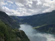
Near the top, pull into Ørnesvingen, the Eagle Turn viewpoint. From here you look straight down into the Geirangerfjord with the Seven Sisters waterfall cascading down the opposite cliff face. Cruise ships appear as toys on the water far below. The parking area is small and often full by mid-morning.

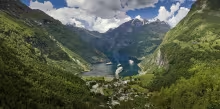
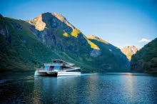
Geiranger and the viewpoints
Geiranger itself is situated at the end of the UNESCO-listed Geirangerfjord. The village is small, the facilities good, but the tourist traffic heavy in summer. Stay long enough to take a fjord cruise, or a RIB Fjord safari past the waterfalls, or at minimum drive the four kilometres up to Flydalsjuvet, a rest area and viewpoint that provides the classic panoramic view of the village, the fjord, and the surrounding mountains.
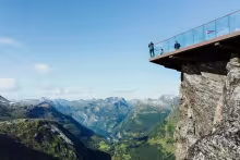
For an even higher perspective, continue 12.5 kilometres beyond Flydalsjuvet to Dalsnibba, at 1,500 metres above sea level. The Nibbevegen road is private and tolled (around 300-400 NOK per car). Whether the toll is worth it depends on the weather: in clear conditions, the view extends far across the horizon, but if the clouds are low you're just paying a lot to see fog.
Route-specific details
Ferry payment: The Eidsdal-Linge crossing is short and frequent. For a single crossing, register at FerryPay, drive on and the fare will automatically be deducted from your credit card. The full-price fare is modest, and tying up a 2,200 NOK deposit for the 50% discount makes no sense for just one crossing. Read more in our Scenic Routes main article.
Direction of travel: Most guides suggest driving north to south (Åndalsnes to Geiranger), which means you will be ascending Trollstigen's most dramatic hairpins. The alternative, driving south to north, means descending Trollstigen, and either way it doesn't make much of a difference.
Combining with other scenic routes: The Atlantic Road is about 1.5 hours north of Åndalsnes, which is at the northern end of the Geiranger-Trollstigen Scenic route. A natural itinerary starts with an overnight in Kristiansund, drives the Atlantic Road in the morning, continues south to the Geiranger-Trollstigen route in the afternoon, and overnights in Geiranger, or the other way around.
Other scenic routes
Check out these other scenic routes in Norway
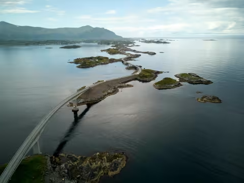
Atlantic Road scenic route self-driving
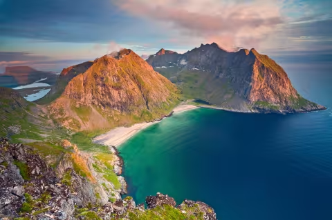
7-day Lofoten scenic route self-drive itinerary
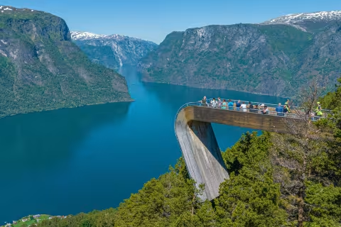
Aurlandsfjellet scenic road to Stegastein
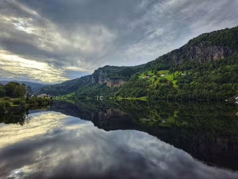
Hardangerfjord scenic route from Bergen
Hardangervidda scenic road self-drive

Explore the locations